Ancient Flood Channels Cut Deep into Mars
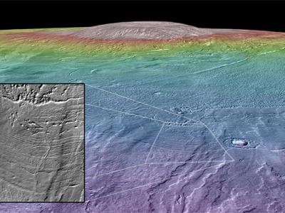
The location of the ~1000 kilometer Marte Vallis channel system on Mars. Marte Vallis is filled with young lavas obscuring the source and morphology of the channels.
Relatively recently, water blasted out from an underground aquifer on Mars, carving out deep flood channels in the surface that were later buried by lava flows, radar images complied from an orbiting NASA probe shows.
The channels are at least twice as deep as previous estimates for Marte Vallis, an expanse of plains just north of the Martian equator that is the youngest volcanic region on the planet.
Most outflow channels on Mars date back billions of years, when the planet was believed to be warmer and wetter than the cold, dry desert it is today.
Marte Vallis is the exception. Channels still visible on the surface cut through very young lava flows, indicating liquid water was present in the relatively recent past. But a key piece of the story has been hidden below ground.
Using radar sounding data collected by an instrument on NASA’s Mars Reconnaissance Orbiter, scientists have created the first three-dimensional reconstruction of Marte Vallis, which reveals buried flood channels 1,000 kilometers (621 miles) long and twice as deep as analysis of surface features had suggested.
“From looking at the surface, you can see the channels were there, but you have no idea how deep it was, which is obviously important because the depth tells you something about the amount of erosion and how much water was there,” lead researcher Gareth Morgan, with the Smithsonian Institution in Washington DC, told Discovery News.
“We see similar channels elsewhere on Mars and they are not filled with lava so it’s important to be able to compare different channel systems, and also similar systems on Earth, to give us clues about how they formed,” Morgan said.
The finding indicates that about 500 million years ago, a time when Mars already was presumed to be cold and dry, massive flooding was still under way, perhaps contributing to a global climate change.
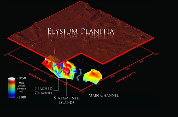
The radar maps also for the first time point to the source of the flooding, a now-buried portion of a fractured region known as Cerberus Fossae, located west of Marte Vallis.
The scientists did not give an estimate of how much water was needed to carve the channels, which are at least as deep as between 75 meters, (246 feet) to 110 meters (361 feet) beneath the surface.
The channels compare to the largest-scale flood channels found on Earth, which are located in eastern Washington, in the Pacific northwest.
While radar instruments aboard NASA’s Mars Reconnaissance Orbiter and Europe’s Mars Express spacecraft are “very capable, most of the rock layers on Mars are not especially cooperative,” geologist Jeffrey Plaut, with NASA’s Jet Propulsion Laboratory in Pasadena, Calif., told Discovery News.
“Most of the targets where we see interesting things underground are in ice, but this particular place is a relatively young volcanic terrain, so we’re seeing through solid rock, basically,” Plaut said.
“What’s really interesting is that the patterns of the layers that we see across these channels tells us something of the history of how those channels evolved,” Plaut added.
The research is reported in this week’s Science.
Mar 7, 2013 02:00 PM ET by Irene Klotz