Opinion: Sizing Up Google’s New North Korea Map
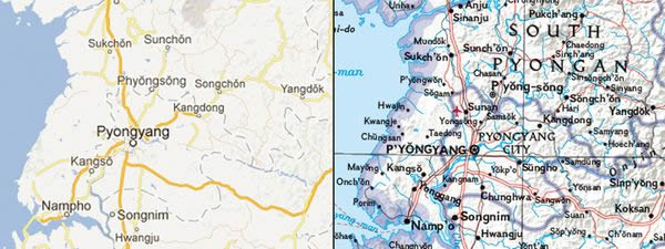
Google's map of North Korea (left), and National Geographic's version (right).
Editor's note: Juan José Valdés is National Geographic's geographer and director of editorial and research for National Geographic Maps.
Google this week unveiled its first detailed maps of North Korea.
Where most of the reclusive police state had formerly appeared as white space, the new maps include street names in the capital, government buildings and businesses, and four sites that Google identifies as gulags.
The Internet search company noted that the project was made possible by citizen cartographers, who for years have been adding the names of roads and points of interest through Google's online Map Maker tool.
"As a result," Google said in a blog post this week, "the world can access maps of North Korea that offer much more information and detail than before."
It's certainly a commendable task. North Korea is among the hardest places on Earth from which to obtain information, let alone accurate cartographic data.
The advent of the fax machine, followed by the Web, has lessened this task. Map sources―specifically satellite imagery―as well as experts on obscure or secretive places like North Korea, are more readily accessible than ever before.
Google's new Korea maps speak to today's bottom-up approach to mapmaking. Traditionally, national survey offices and cartographic houses have dictated map content.
But that tradition has quickly lost ground with the emergence of dynamic mapping platforms and the legions of citizen cartographers who have begun making and updating maps.
The best example of this movement is the OpenStreetMap project. Since its founding in 2004, over a million worldwide participants have―with the aid of satellite and aerial imagery, GPS, and hard-copy sources―catalogued everything from foot trails and bike paths to handicapped-accessible buildings in some of the world's major cities.
While the democratization of mapmaking has much to add to an old science by allowing anyone with access to a computer to upload their findings, it's also important that we acknowledge the pitfalls and limits of citizen cartography.
In many parts of the world such citizen mapping has proven challenging, if not downright dangerous. In many places, little can be achieved without the approval of local and or national authorities―especially in North Korea.
When attempting to map contentious areas, National Geographic not only works closely with individual governmental entities but also with external entities, including international toponymic (place-naming) authorities and agencies such as the United Nations.
At the other end of the spectrum there's the issue of a citizen cartographer's knowledge or understanding of official naming or boundary policies.
It's one thing to record and portray place-names on a map as recognized by locals or wondering citizen cartographers. It's quite another for them to abide by the official cartographic policies of the territories they are mapping.
In many countries, place-names, let alone the alignment of boundaries, remain a powerful symbol of independence and national pride, and not merely indicators of location. This is where citizen cartographers need to understand the often subtle nuances and potential pitfalls of mapping.
From National Geographic's perspective, all a map should accomplish is the actual portrayal of national sovereignty, as it currently exists. It should also reflect the names as closely as possible to those recognized by the political entities of the geographic areas being mapped.
To do otherwise would give map readers an unrealistic picture of what is occurring on the ground.
If not cognizant of these facts, there is a real danger that certain parts of the world could be erroneously mapped.
Such errors could, and have had, international repercussions. In 2000, an incorrect alignment of the Costa Rican-Nicaraguan border on Google Maps inflamed tensions between the two countries. Google quickly corrected the error.
Over the centuries, cartography has witnessed many "golden ages." Today, experts are proclaiming that we are in the midst of a new one.
A profession once practiced by few has become a discipline enthusiastically engaged by many. Unlike printed maps, where an error―as with the recent find of the phantom Sandy Island in the South Pacific―can be perpetuated through time, online maps enable such errors to be quickly corrected.
What better face-saving device could a cartographer ask for?
Juan José Valdés
National Geographic News
Published January 31, 2013